Share Glen Cairn Neighbourhood Connectivity Plan on FacebookShare Glen Cairn Neighbourhood Connectivity Plan on TwitterShare Glen Cairn Neighbourhood Connectivity Plan on LinkedinEmail Glen Cairn Neighbourhood Connectivity Plan link
About this project
As part of its commitment to providing safe, convenient and accessible mobility choices for all residents, City Council has directed staff to develop a “Neighbourhood Connectivity Plan” (NCP) for the Glen Cairn area. The plan will identify where new sidewalks can provide the most value.
Throughout the month of June 2022, City staff consulted with your community to get input to help shape your neighbourhood’s plan. Based on feedback from residents, and data and information from community partners, the project team has developed recommendations for where sidewalks and connectivity should be prioritized in your neighbourhood. To preview the NCP recommendations for Glen Cairn, see below for a map and supporting information.
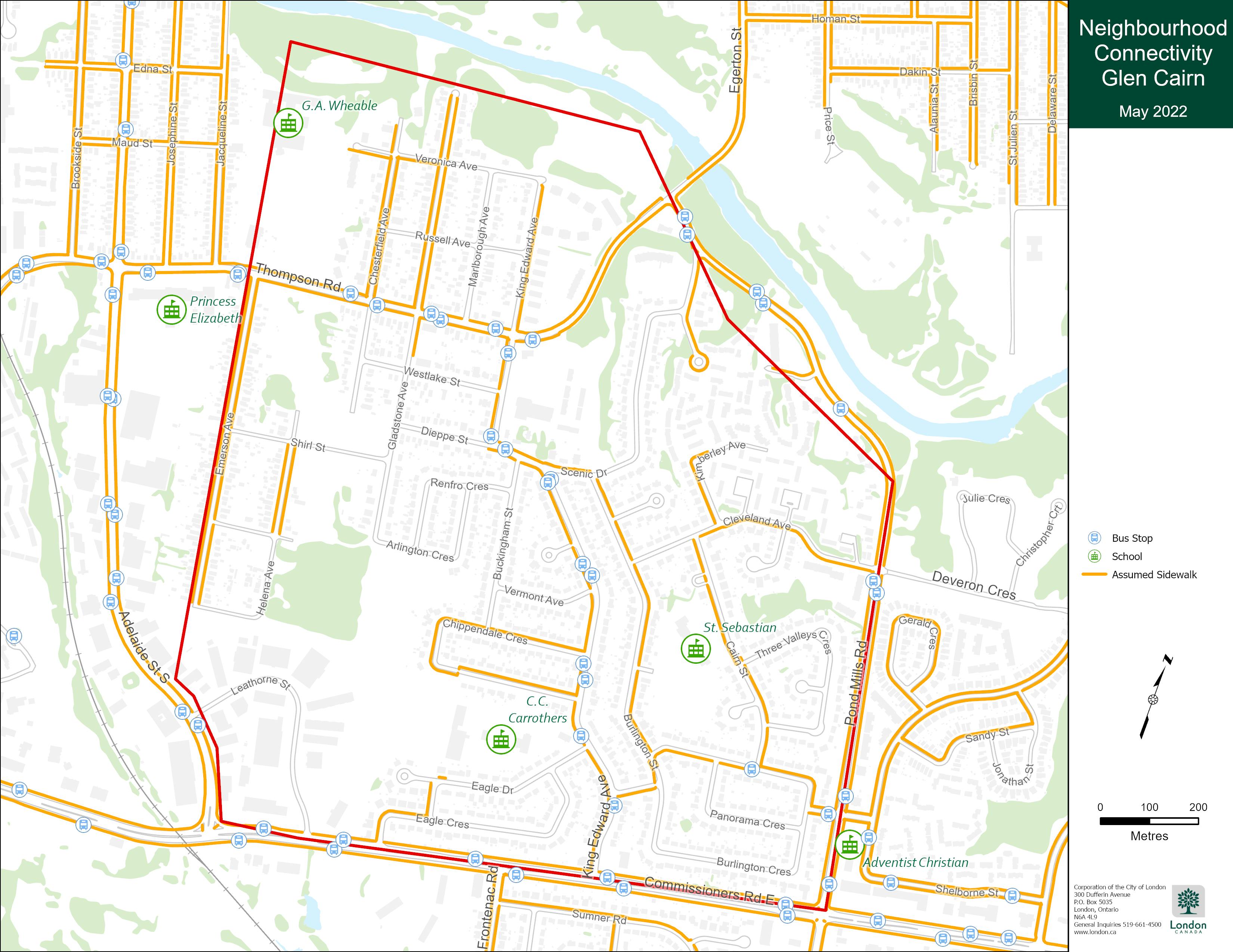
NCP Recommendations for Glen CairnAbove: Map graphic showing recommended new sidewalk connections for the Glen Cairn area
Table 2: Glen Cairn Neighbourhood Connectivity Plan Recommendations
Street
Timing
Location
Program*
Sidewalk recommended on one side of the street:
Veronica Avenue
TBD
Gladstone Avenue to King Edward Avenue
TBD
Marlborough
TBD
Gladstone Avenue to King Edward Avenue
TBD
Russell Avenue
TBD
Thompson Road to Veronica Avenue
TBD
King Edward Avenue
2029
Scenic Drive to King Edward Avenue N.
IRLP
King Edward Avenue
>10yrs
Thompson Road to Dieppe Street
IRLP
Scenic Drive
2029
Pond Mills Road to King Edward Avenue N.
IRLP
Westlake Street
>10yrs
Gladstone Avenue to King Edward Avenue
IRLP
Shirl Street
2026
Emerson Avenue to Gladstone Avenue
IRLP
Dieppe Street
>10yrs
Gladstone Avenue to King Edward Avenue
IRLP
Marion Street
>10yrs
Emerson Avenue to Helena Avenue
IRLP
Helena Avenue
>10yrs
Marion Street to Baseline Road
IRLP
Cleveland Avenue
>10yrs
Burlington Street to Cairn Street
IRLP
Vermont Avenue
TBD
Buckingham Street to King Edward Avenue
TBD
Buckingham Street
TBD
King Edward Avenue to Chippendale Crescent
NSP
Eagle Drive
2030
Eagle Drive to King Edward Avenue
IRLP
Leathorne Street
TBD
Adelaide Street to Commissioners Road
TBD
New Pedestrian Crossing for Consideration:
Pond Mills Road
Monitor
New crossing at Cleveland Avenue
RSS
King Edward Avenue
Monitor
New Crossing between Dieppe and Burlington
RSS
Cairn Street
Monitor
New crossing at Three Valleys Crescent N.
RSS
Other Considerations:
Consider opportunities to improve pedestrian connection over Thompson Road Bridge
Consider opportunities to create pedestrian connection to Adelaide from Helena/Baseline.
* Sidewalks and pedestrian supportive infrastructure are constructed under various programs:
As part of its commitment to providing safe, convenient and accessible mobility choices for all residents, City Council has directed staff to develop a “Neighbourhood Connectivity Plan” (NCP) for the Glen Cairn area. The plan will identify where new sidewalks can provide the most value.
Throughout the month of June 2022, City staff consulted with your community to get input to help shape your neighbourhood’s plan. Based on feedback from residents, and data and information from community partners, the project team has developed recommendations for where sidewalks and connectivity should be prioritized in your neighbourhood. To preview the NCP recommendations for Glen Cairn, see below for a map and supporting information.
NCP Recommendations for Glen CairnAbove: Map graphic showing recommended new sidewalk connections for the Glen Cairn area
Table 2: Glen Cairn Neighbourhood Connectivity Plan Recommendations
Street
Timing
Location
Program*
Sidewalk recommended on one side of the street:
Veronica Avenue
TBD
Gladstone Avenue to King Edward Avenue
TBD
Marlborough
TBD
Gladstone Avenue to King Edward Avenue
TBD
Russell Avenue
TBD
Thompson Road to Veronica Avenue
TBD
King Edward Avenue
2029
Scenic Drive to King Edward Avenue N.
IRLP
King Edward Avenue
>10yrs
Thompson Road to Dieppe Street
IRLP
Scenic Drive
2029
Pond Mills Road to King Edward Avenue N.
IRLP
Westlake Street
>10yrs
Gladstone Avenue to King Edward Avenue
IRLP
Shirl Street
2026
Emerson Avenue to Gladstone Avenue
IRLP
Dieppe Street
>10yrs
Gladstone Avenue to King Edward Avenue
IRLP
Marion Street
>10yrs
Emerson Avenue to Helena Avenue
IRLP
Helena Avenue
>10yrs
Marion Street to Baseline Road
IRLP
Cleveland Avenue
>10yrs
Burlington Street to Cairn Street
IRLP
Vermont Avenue
TBD
Buckingham Street to King Edward Avenue
TBD
Buckingham Street
TBD
King Edward Avenue to Chippendale Crescent
NSP
Eagle Drive
2030
Eagle Drive to King Edward Avenue
IRLP
Leathorne Street
TBD
Adelaide Street to Commissioners Road
TBD
New Pedestrian Crossing for Consideration:
Pond Mills Road
Monitor
New crossing at Cleveland Avenue
RSS
King Edward Avenue
Monitor
New Crossing between Dieppe and Burlington
RSS
Cairn Street
Monitor
New crossing at Three Valleys Crescent N.
RSS
Other Considerations:
Consider opportunities to improve pedestrian connection over Thompson Road Bridge
Consider opportunities to create pedestrian connection to Adelaide from Helena/Baseline.
* Sidewalks and pedestrian supportive infrastructure are constructed under various programs:
Help us understand your community travel patterns and establish key neighbourhood destinations, features and amenities by taking this survey.
Note: Please give us your feedback by either using the map OR completing this survey. If you have already entered your feedback through the map, you do not need to duplicate your answers here.
Share Survey on FacebookShare Survey on TwitterShare Survey on LinkedinEmail Survey link
Page last updated: 20 Jan 2023, 06:24 AM
Process for developing a Neighbourhood Connectivity Plan
Community consultation
Glen Cairn Neighbourhood Connectivity Plan has finished this stage
Community consultation closed on July 1, 2022. Thank you to everyone who met with us at in-person opportunities, participated in our virtual webinar, used the website, or called us to provide input.
Recommendations to City Council
Glen Cairn Neighbourhood Connectivity Plan is currently at this stage
With community consultation finished, staff will bring a report to Council on January 31, 2023 highlighting recommendations for your neighbourhood.
Street-level consultation
this is an upcoming stage for Glen Cairn Neighbourhood Connectivity Plan
With Council approval of your Neighbourhood Connectivity Plan, staff will come back to the streets where sidewalks have been recommended to consult with those residents to determine the best sidewalk design for the street.

 Above: Map graphic showing recommended new sidewalk connections for the Glen Cairn area