Northridge Neighbourhood Connectivity Plan
Consultation has concluded
About this project
As part of its commitment to providing safe, convenient and accessible mobility choices for all residents, City Council has directed staff to develop a “Neighbourhood Connectivity Plan” for the Northridge area. The plan will identify where new sidewalks can provide the most value.
During the latter half of June and into July, City staff consulted with your community to get input to help shape your neighbourhood's plan. Thank you to everyone who provided feedback in person, by email, by phone, or through the website.
Based on feedback from residents, and data and information from community partners, the project team has developed recommendations for consideration regarding where sidewalks and connectivity should be prioritized in your neighbourhood. To preview the NCP recommendations for Northridge, see below for a map and supporting information.
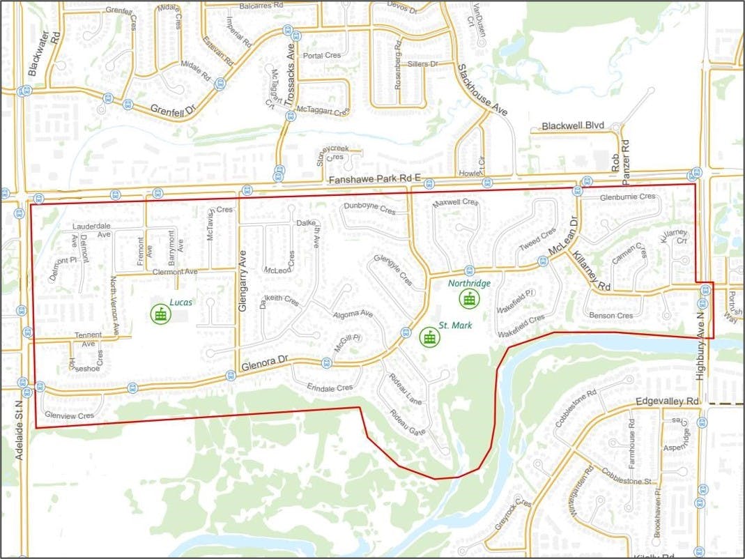
NCP Recommendations for Northridge Above: A map graphic showing locations of new sidewalk connections recommended for Northridge, colour coded to indicate the earliest possible timeframe when roads would be undergo lifecycle renewal.
The Northridge NCP recommends 11 strategic sidewalk connections to improve pedestrian connectivity and 24 sidewalk exemptions from Mobility Policy 349.
Street | Timing | Location | Program* |
Sidewalk recommended on one side of the street: | |||
Lauderdale Avenue | 1-5 years | West limit to Barrymont Avenue | LRRP |
North Vernon Avenue | 10+ years | Lauderdale Avenue to Clermont Avenue | LRRP |
Tennent Avenue | 1-5 years | Glengarry Avenue to A.B. Lucas Secondary School | NSP |
Barrymont Avenue | 1-5 years | Lauderdale Avenue to Clermont Avenue | LRRP |
Dalkieth Avenue | 1-5 years | Glengarry Avenue to Glengarry Avenue | LRRP |
Algoma Avenue | 6-10 yrs | Dalkeith Avenue to Glenora Drive | LRRP |
Glengyle Crescent | 6-10 yrs | Glenora Drive to Dalkeith Park access | LRRP |
Dunboyne Crescent | 1-5 years | Glenora Drive to Dalkieth Park access | LRRP |
Maxwell Crescent | 1-5 years | McLean Drive to Fanshawe Optimist Park Access | LRRP |
Tweed Crescent | 10+ years | McLean Drive to Fanshawe Optimist Park Access | LRRP |
Sidewalk recommended on the second side of the street: | |||
Glengarry Avenue | 6-10 yrs | Clermont Avenue to Fanshawe Park Road | NSP |
Barrymont Avenue | 1-5 years | Clermont to A.B. Lucas Secondary School | LRRP |
New pedestrian crossing for consideration: | |||
Glenora Drive | Monitor | New crossing at the pathway connections west of Glengarry Avenue | RSS |
McLean Drive | Monitor | New crossing at Killarney Road | RSS |
Fremont Avenue | Monitor | New crossing at Lauderdale Avenue | RSS |
Glengarry Avenue | Monitor | New crossing at north leg of Dalkeith Avenue | RSS |
New pedestrian signal for consideration: | |||
Fanshawe Park Road | Monitor | New signal at Glenora Drive | RSS |
Sidewalks and pedestrian supportive infrastructure are constructed under various programs:
- IRLP – Infrastructure Lifecycle Renewal Program
- LRRP – Local Road Reconstruction Program
- NSP – New Sidewalk Program
- RSS – Road Safety Strategy
- TBD – Program/Timeline is To Be Determined
Update
Following Civic Works Committee, Council met on November 28 to give final direction on the staff recommendations. Four of the 11 recommended streets were approved to receive new sidewalks:
- Tennent Avenue
- Barrymont Avenue
- North Vernon Avenue
- Lauderdale Avenue
Seven of the 11 recommended streets were exempted from the recommendation to receive new sidewalks:
- Glengarry Avenue
- Dalkeith Avenue
- Algoma Avenue
- Glengyle Crescent
- Dunboyne Crescent
- Maxwell Crescent
- Tweed Crescent
When it’s time to reconstruct any of these four streets where sidewalks have been approved, staff will then return to consult with those residents, with a focus on finding the best fit for the street and helping residents understand the design considerations available to maximize the benefits and mitigate impacts of adding a new sidewalk.
Please contact the NCP team if you have any questions about next steps.
Project recap
If you missed your neighbourhood's webinar, you can still view a recording of the presentation here: https://bit.ly/3JX1dor