Grenfell Neighbourhood Connectivity Plan
About this project
As part of its commitment to providing safe, convenient and accessible mobility choices for all residents, City Council has directed staff to develop a “Neighbourhood Connectivity Plan” (NCP) for the Grenfell area. The plan will identify where new sidewalks can provide the most value.
Throughout the month of June 2022, City staff consulted with your community to get input to help shape your neighbourhood’s plan. Based on feedback from residents, and data and information from community partners, the project team has developed recommendations for where sidewalks and connectivity should be prioritized in your neighbourhood. To preview the NCP recommendations for Grenfell, see below for a map and supporting information.
NCP Recommendations for Grenfell
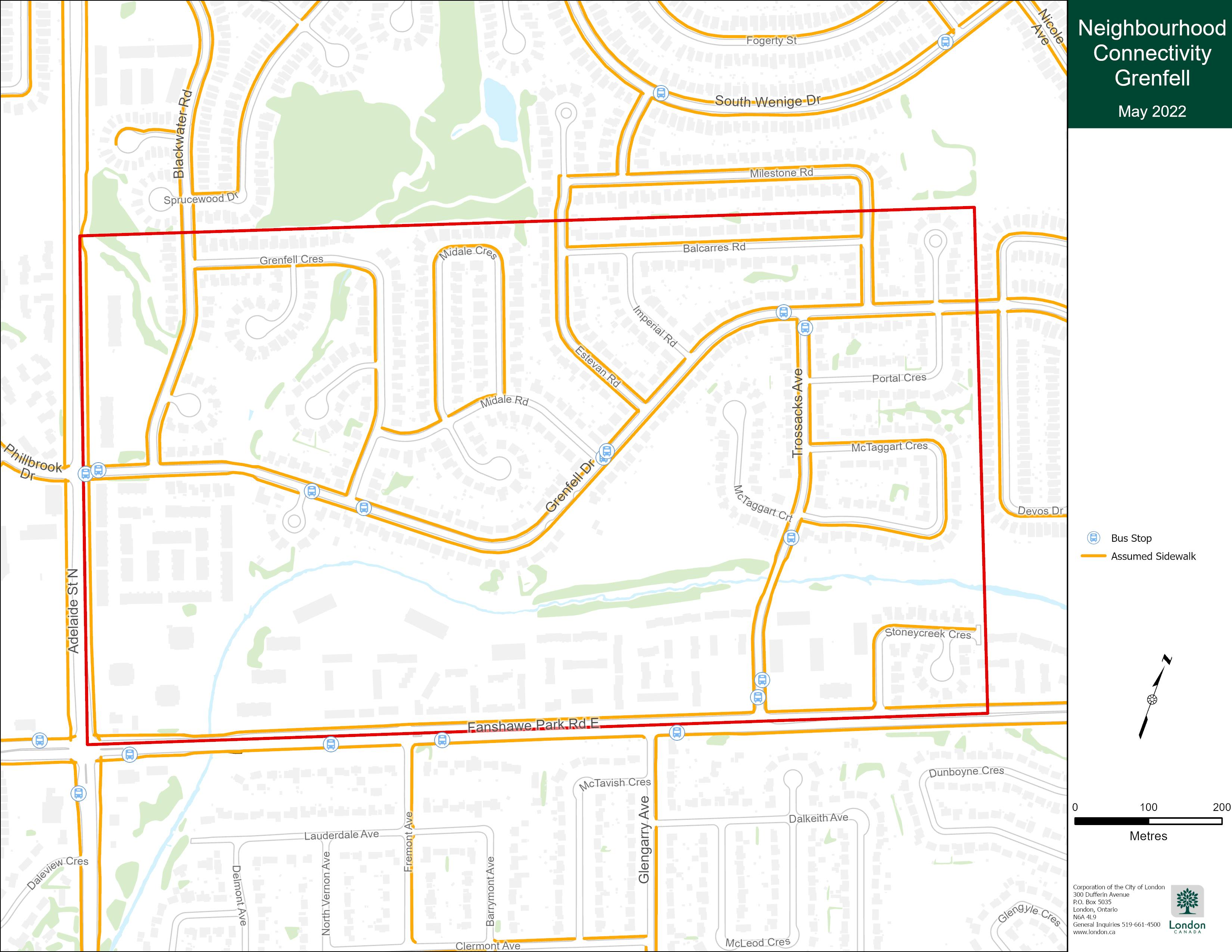
 Above: Map graphic showing recommended new sidewalk connections for the Grenfell area
Table 2: Glenfell Neighbourhood Connectivity Plan Recommendations
Street | Timing | Location | Program* |
Sidewalk recommended on one side of the street: | |||
Midale | 0-2yrs | Midale Crescent to Grenfell Drive | NSP |
New pedestrian crossing to be considered: | |||
Trossacks Avenue | Monitor | crossing at the Stoney Creek Trail | RSS |
Other recommendations: | |||
Engage with the Thames Valley District School Board to potentially extend dead end pathway in Wenige Park to Stoney Creek Public School. | |||
Consider options for “No U-Turn” or other signage on Nicole Avenue to encourage parents to use the robust “Kiss-n-drop” facility on school property zones rather than u-turns from the school bus bay or using private drives. | |||
* Sidewalks and pedestrian supportive infrastructure are constructed under various programs:
- ILRP – Infrastructure Renewal Program
- LRRP – Local Road Reconstruction Program
- NSP – New Sidewalk Program
- RSS – Road Safety Strategy
Next steps
City staff will be bringing a report with recommendations on where new sidewalks should be implemented in your neighbourhood to City Council’s Civic Works Committee on January 31, 2023. This staff report will be available to preview online on the City of London’s website at this link at noon on January 26.
This meeting includes a public participation meeting (PPM) component, meaning you can speak directly to the Civic Works Committee at this meeting, either remotely or in-person. Remote participation requires preregistration through the Clerk’s Office. For more information on the PPM process, visit the City of London website at this link.
The January 31 Civic Works Committee meeting will also be available to livestream on the City of London’s YouTube channel.
With Council’s direction, staff would come back to any specific streets where sidewalks have been approved to consult with those residents. At that point, staff would focus on finding the best fit for the street and helping residents understand the design considerations available to maximize the benefits, and mitigate impacts of, adding a new sidewalk.
Project recap
If you missed your neighbourhood’s webinar, you can still view a recording of the presentation here: https://www.youtube.com/watch?v=BLSPAkaOZV8&feature=youtu.be