Huron Heights Neighbourhood Connectivity Plan
Consultation has concluded
About this project
As part of its commitment to providing safe, convenient and accessible mobility choices for all residents, City Council has directed staff to develop a “Neighbourhood Connectivity Plan” for the Huron Heights area. The plan will identify where new sidewalks can provide the most value.
During the latter half of June and into July, City staff consulted with your community to get input to help shape your neighbourhood's plan. Thank you to everyone who provided feedback in person, by email, by phone, or through the website.
Based on feedback from residents, and data and information from community partners, the project team has developed recommendations for consideration regarding where sidewalks and connectivity should be prioritized in your neighbourhood. To preview the NCP recommendations for Huron Heights, see below for a map and supporting information.
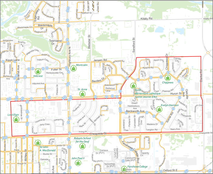
NCP Recommendations for Huron Heights

Above: A map graphic showing locations of new sidewalk connections recommended for Huron Heights, colour-coded to indicate the earliest possible timeframe when roads would be undergo lifecycle renewal.
The Huron Heights NCP recommends 20 strategic sidewalk connections to improve pedestrian connectivity and the exemption of 24 crescents or short streets and 14 courts from Mobility Policy 349.
Table: Huron Heights Neighbourhood Connectivity Plan Recommendations
Street | Timing | Location | Program* |
Sidewalk recommended on one side of the street: | |||
Victoria Drive | 10+ years | Cheapside Street to McNay Street | LRRP |
Genevive Crescent | 6-10 yrs | Victoria Drive to second pathway connection | LRRP |
Michaelmas Street | 10+ years | Rock Street to Victoria Drive | LRRP |
Rock Street | 10+ years | McNay Street to Michaelmas Street | LRRP |
Patann Drive | 1-5 years | Michael Street to Godfrey Drive | LRRP |
Godfrey Drive | 1-5 years | Highbury Avenue to Patann Drive | LRRP |
Susan Avenue | 6-10 yrs | Patann Drive to Mark Street | LRRP |
Mark Street | 1-5 years | Susan Drive to Irving Place | NSP |
Michael Street | 1-5 years | Cheapside Street to Michael Circle | NSP |
Tewksbury Crescent | 1-5 years | Perth Avenue to Sorrel Road | NSP |
Perth Avenue | 6-10 yrs | West end path connection to easterly path connection. | LRRP |
Perth Street | 6-10 yrs | Perth Avenue to Huron Street | LRRP |
Sorrel Road | 10+ years | West side from Tewksbuy Drive to Cheapside Street | LRRP |
Farnsborough Crescent | 10+ years | Cheapside Street to Langton Road | LRRP |
Langton Road | 10+ years | Farnsborough Crescent to Beckworth Avenue | LRRP |
Kaladar Drive | 1-5 years | Sorrel Road to Cheapside Street | LRRP |
Cayuga Crescent | 1-5 years | Chippewa Drive to Oakville Avenue | LRRP |
Pawnee Road | 1-5 years | Chippewa Drive to Oakville Avenue | LRRP |
Pawnee Gate | 6-10 yrs | Pawnee Road to Huron Street | LRRP |
Stronach Crescent | 10+ years | Clarke Road to Clarke Road | LRRP |
Arterial Road Improvement: | |||
Huron Street | 10+ years | Perth Street to Clark Road | ARRP |
New pedestrian crossing to be considered: | |||
Oakville Avenue | Monitor | Review existing crossing at Tilipe Road | RSS |
Oakville Avenue | Monitor | Review potential crossing at Cayuga Crescent | RSS |
Other traffic control considerations: | |||
Oakville Avenue at Chippewa Drive | Monitor | Review intersection for potential traffic control upgrades | RSS |
* Sidewalks and pedestrian supportive infrastructure are constructed under various programs:
- ILRP – Infrastructure Renewal Program
- LRRP – Local Road Reconstruction Program
- NSP – New Sidewalk Program
- ARRP – Arterial Road Reconstruction Project
- RSS – Road Safety Strategy
Update
Following Civic Works Committee, Council met on November 28 to give final direction on the staff recommendations. 17 of the 20 recommended streets were approved to receive new sidewalks:
- Victoria Drive
- Genevive Crescent
- Michaelmas Street
- Rock Street
- Patann Drive
- Godfrey Drive
- Susan Avenue
- Michael Street
- Tewksbury Crescent
- Perth Avenue
- Perth Street
- Sorrel Road
- Farnsborough Crescent
- Langton Road
- Pawnee Road
- Pawnee Gate
- Stronach Crescent
Three of the 20 recommended streets were exempted from the recommendation to receive new sidewalks:
- Kaladar Drive
- Cayuga Crescent
- Mark Street
When it’s time to reconstruct any of these four streets where sidewalks have been approved, staff will then return to consult with those residents, with a focus on finding the best fit for the street and helping residents understand the design considerations available to maximize the benefits and mitigate impacts of adding a new sidewalk.
Please contact the NCP team(External link) if you have any questions about next steps.
What happens after City Council’s decision?
Following Civic Works Committee, Council will meet on November 28 to give final direction on the staff recommendations. When it’s time to reconstruct any specific streets where sidewalks have been approved, staff would then return to consult with those residents, with a focus on finding the best fit for the street and helping residents understand the design considerations available to maximize the benefits and mitigate impacts of adding a new sidewalk.
Please contact the NCP team if you have any questions about next steps.
Project recap
If you missed your neighbourhood's webinar, you can still view a recording of the presentation: https://bit.ly/3rw4zZl